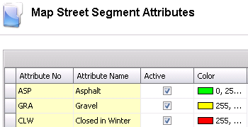
Map Street Segment Attributes are used to define certain types of road conditions. For example, asphalt, gravel, closed in winter. A color can be assigned to the attribute to be displayed on the map.
Table Name: MtSysMapStreetSegments
In Admin>Business>General>Maps, select Street Segment Attributes.
Select the  button to create
a new record.
button to create
a new record.
Enter the Attribute Name to describe the attribute. Alphanumeric, max 255 characters
The Active flag will be selected by default. De-select the flag if the attribute is no longer used or active.
The Color field can be used to enter an identifying color for the attribute
Save and Close the record.